

From 40 TB to 10 TB: how CIMA+ shrank its point cloud footprint by 75%, without losing a single point
Their previous platform billed every scan position and demanded heavy structured scans to keep images and points connected. VL365 broke the lock: same precision, same immersive views, a quarter of the data, and the freedom to publish any point cloud from any scanner.
40 → 10
Terabytes hosted
−75%
Storage footprint
0
Loss in precision, density or accuracy
Project overview
One field dataset, in a freer container
- Customer
- CIMA+, one of Canada's largest multidisciplinary engineering consulting firms
- Champion
- Sylvain Lefevre, Associate Partner / Senior Manager, Reality Capture and Geomatics, CIMA+
- Industry
- Engineering, infrastructure & reality capture
- Data
- Terrestrial and mobile / SLAM laser scanning: structured projects in .lsproj (FLS series) and E57
- Platform scope
- Any point cloud source (terrestrial TLS, mobile mapping, SLAM, drone / aerial LiDAR) in one pipeline
- Before
- 40 TB of structured scans on their previous cloud platform: billed per scan position, structured format mandatory
- After
- 10 TB of unified scans on VL365: same coverage, same precision, no per-position billing
- Result
- 75% smaller footprint, cost decoupled from field campaigns, total format freedom
The problem
A pricing model that punished fieldwork, and a format they couldn't escape
Every reality capture project at CIMA+ starts the same way: scanners deployed at dozens, sometimes hundreds, of positions across a site, terrestrial units on tripods and mobile systems in motion. Each position produces a structured scan: its own file, its own panoramic imagery, its own overlap with the neighbouring stations.
Here's the trap. Their previous platform billed by the scan position. Not by value delivered, not even by data stored. A position weighing 100 MB cost exactly the same as one weighing 1 GB. And to keep the imagery matched to the point cloud, the platform required structured scans: the heaviest possible way to carry the data, locked in with no alternative. The invoice was chained to how the team worked in the field, and the format was chained to the platform.
The math was merciless: the more the team scanned, the better they did their job, the more they paid. Forty terabytes of structured data online, and every new campaign made it worse. Doing excellent work had become the most expensive thing the team could do.
The challenge, in five pain points
Billed by the scan position
Every tripod setup, every station was an invoice line. Costs tracked field effort, not business value.
Format lock-in
Structured scans were mandatory to keep images and points connected. The heaviest format in the industry, imposed by contract. Zero flexibility.
Massive redundancy
The same geometry was captured and stored from multiple overlapping stations, project after project, 40 TB deep.
Heavy, slow sharing
Reviewers and clients waited for transfers of structured data instead of opening a link in a browser.
A model that couldn't scale
With terrestrial and mobile campaigns already running and drone capture on the horizon, every new sensor meant more positions, more lock-in, more cost.
The shift
From structured to unified. Same points, lighter container, no more chains.
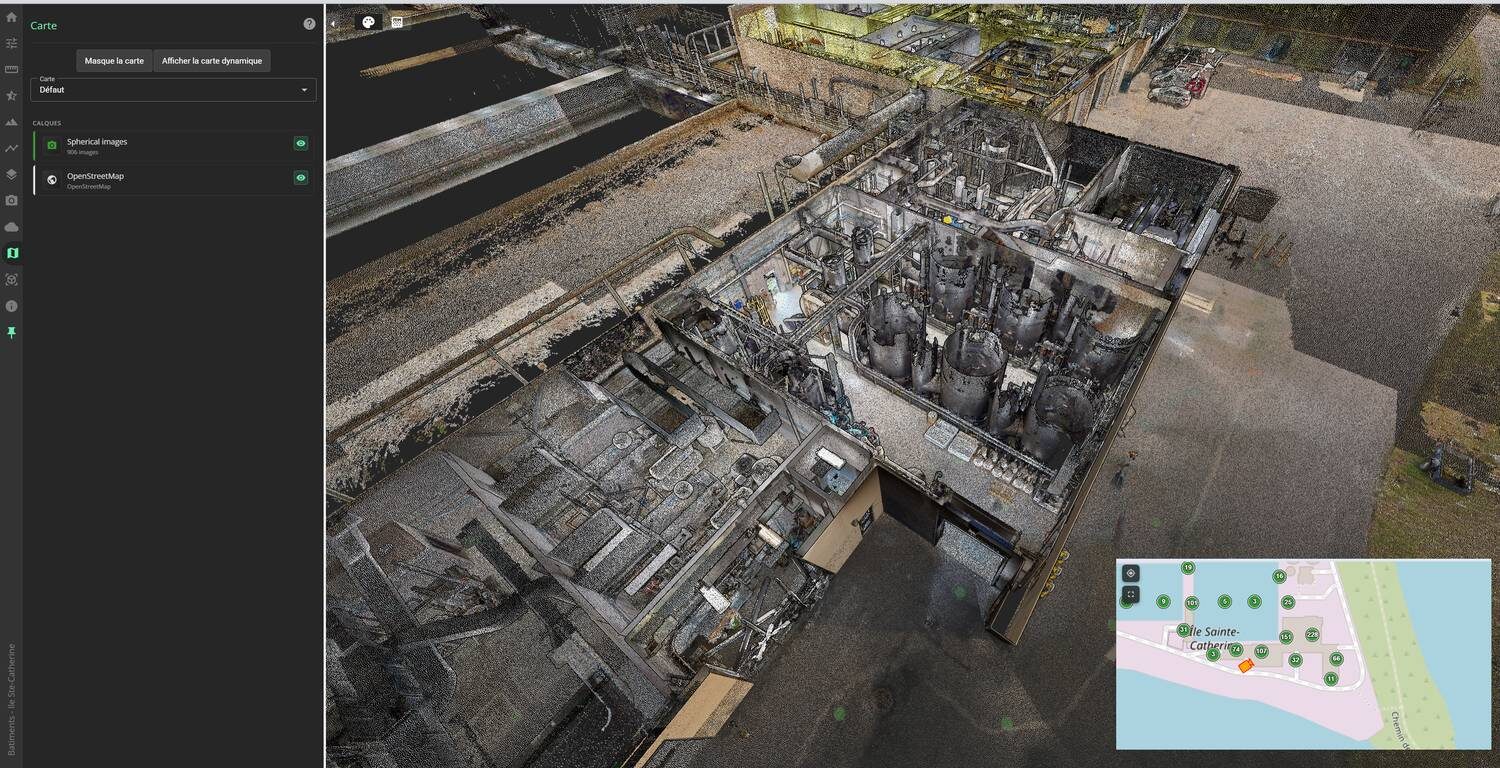
A unified scan merges every station into one clean, deduplicated point cloud. The redundant overlap disappears; the geometry doesn't. Every point that matters is still there, at the same coordinates, at the same density where it counts.
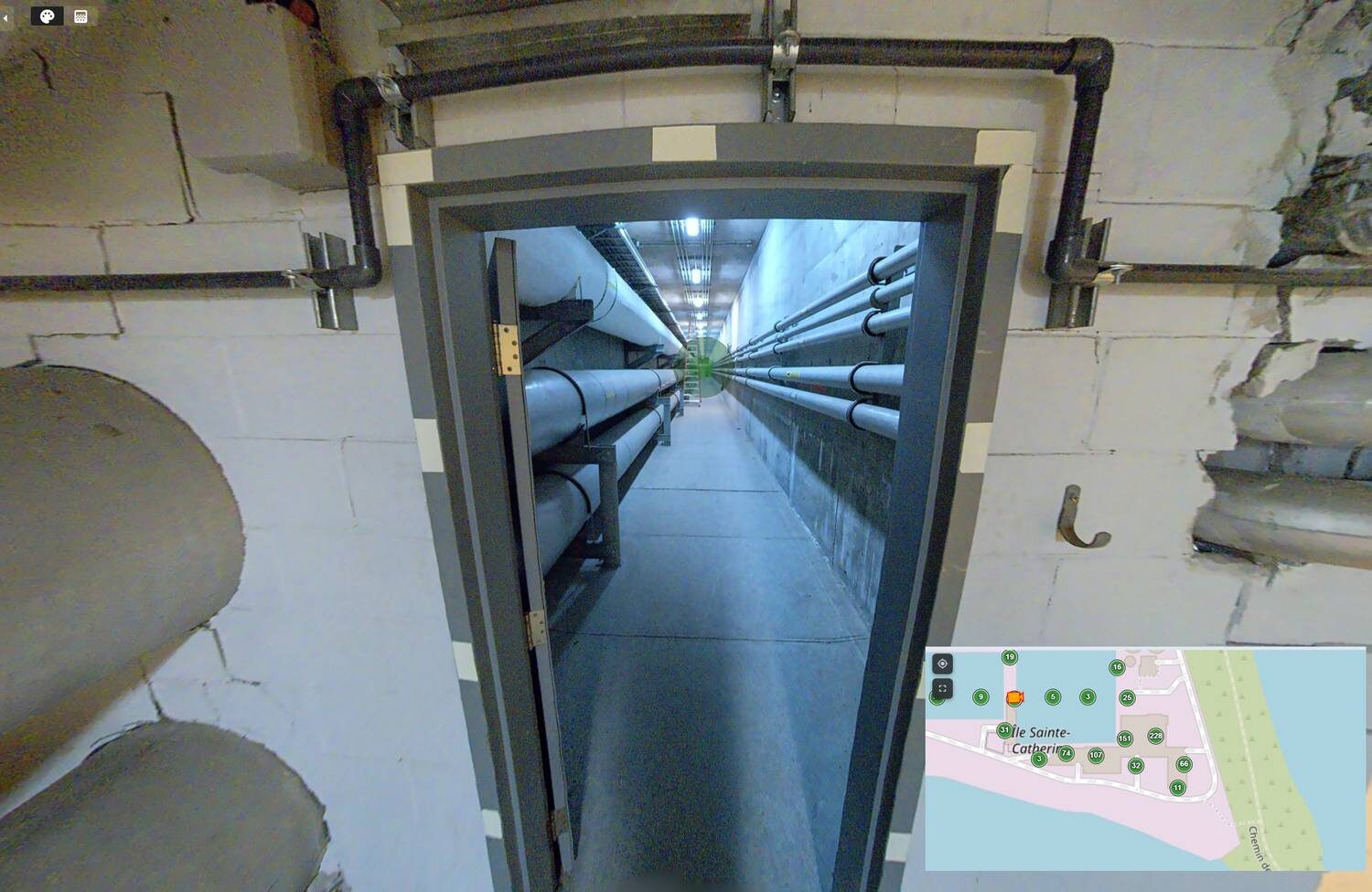
Exported as LAZ, the open industry-standard format, the unified cloud is accompanied by the trajectory files and the JPG spherical images from VisionLidar. The image-to-point connection survives intact. You still “stand” at any scanner position and look around in 360°.
And for anyone worried about quality: nothing about the measurement changes. Precision, density and accuracy are properties of the points, not of the file that carries them. The migration only changes the container: out with the heavy, duplicated, mandated format; in with a light, unified, open one.
What changed, and what didn't
Structured scans (blue) vs. unified LAZ on VL365 (green), indexed to 100
The workflow
Step by step
The entire conversion runs through VisionLidar desktop. No third-party tools, no format gymnastics. Here is exactly what a technician does, file in, file out.
- 1
Import the raw structured scans into VisionLidar desktop
Drop the field data in as-is: FARO projects as .lsproj (the series of FLS station files) and E57 files from terrestrial, mobile and SLAM scanners. A structured scan means one file per scanner position with the panoramic photos embedded inside, and that's exactly what VisionLidar reads. No pre-processing, no conversion utility, no re-registration.
- 2
Open and validate the project
The assembled project opens in the full 3D environment. The technician checks registration, colorization, station positions and the spherical imagery station by station. What you validate on screen is exactly what gets published.
- 3
Export one unified LAZ
One export command merges every station into a single, deduplicated point cloud and writes it as compressed LAZ. Concretely: structured E57 / .lsproj in → one unified LAZ out. Overlap between stations is resolved; coordinates, density, intensity and classification are untouched.
- 4
Export the trajectory file with the JPGs
In the same pass, VisionLidar extracts the panoramic photos from the structured files as standalone JPGs and writes the trajectory file: the exact coordinates and orientation of every scanner position. That pair lets VL365 re-attach each photo to its position in the unified cloud: click a station, stand in the 360° view, points perfectly aligned.
- 5
Publish to VL365
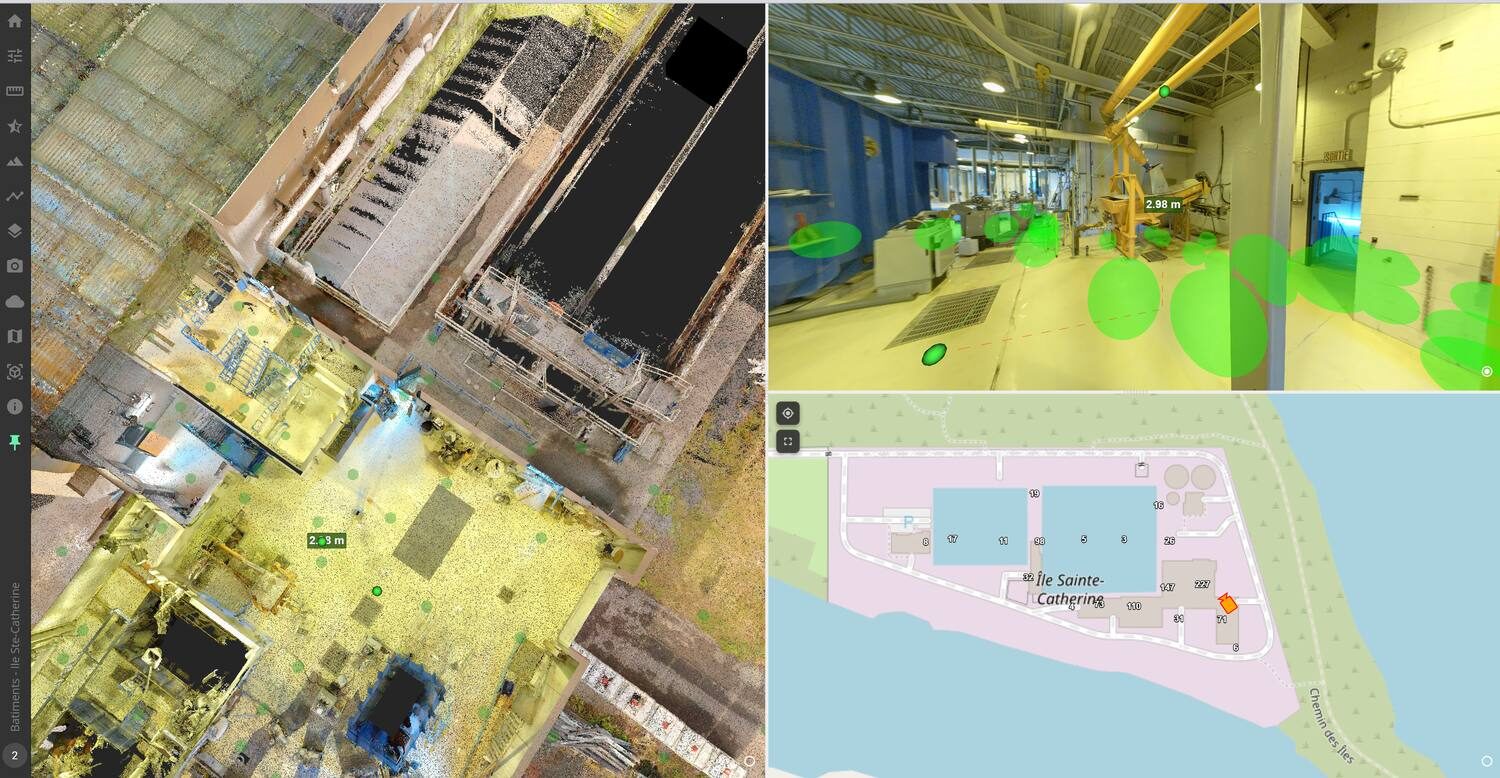
Upload the LAZ + trajectory + JPGs to VL365 (unlimited upload, no per-gigabyte toll), and anyone with a browser can stream the project, stand in the 360° photos, measure, annotate, vectorize and export. No desktop licence required for viewers.
Any point cloud
One pipeline. One platform.
The migration solved today's problem: terrestrial and mobile scans. What made it a strategic decision is that the same pipeline absorbs whatever CIMA+ captures next.
Terrestrial (TLS)
Tripod-mounted static scanners, at the heart of this story. FARO structured projects (.lsproj / FLS) and E57 exchanges import natively, station imagery included.
Mobile mapping & SLAM
Vehicle-mounted, backpack and SLAM scanners, already in CIMA+'s fleet, feeding the same pipeline through E57. VisionLidar treats trajectories as first-class data, not an afterthought.
Drone / aerial
UAV LiDAR and airborne surveys. Wide-area clouds land in the same unified LAZ pipeline and stream from the same VL365 projects.
Tripod, backpack, vehicle or drone: everything enters the same door and comes out as one deliverable. CIMA+ standardized once, and every future campaign, whatever the sensor, lands in a pipeline the team already masters.
Native import formats: no third-party conversion step, no quality lost in translation.
A common data environment (CDE) for your scans
That's the role VL365 ends up playing at CIMA+: the CDE of laser scans. Engineering teams don't transform anything into ReCap or any other heavy format to use the data. The point cloud lives in one place, and any computer that can open a browser has access to the field data, at survey-grade precision, within minutes of capture. Client, methods office, subcontractors, BIM team: the same data, at the same time, without waiting. Your survey data moves as fast as your decisions.
The key features behind the complete solution
No mesh, no converter, a true CDE for scans
Drag & drop in the browser, native scanner formats (Leica, FARO…), no ReCap or heavy intermediate format: any computer with a browser gets survey-grade field data, minutes after capture.
Native multi-format, multi-sensor import
Static, mobile and airborne scans enter one workflow. No conversions means no waiting and no degradation.
Unified LAZ engine, included in the free version
One command deduplicates and compresses an entire structured project into the open industry standard. This is the 75%, and it costs nothing in VisionLidar desktop.
Trajectory + spherical imagery preserved
The immersive station-by-station experience survives unification; nothing the field team loved is sacrificed.
Browser streaming with roles, and noticeably faster
One link replaces file transfers; clients and reviewers get viewer access without a desktop licence, and unified projects being 75% lighter, they open and navigate visibly faster in the app.
Extraction where the data lives
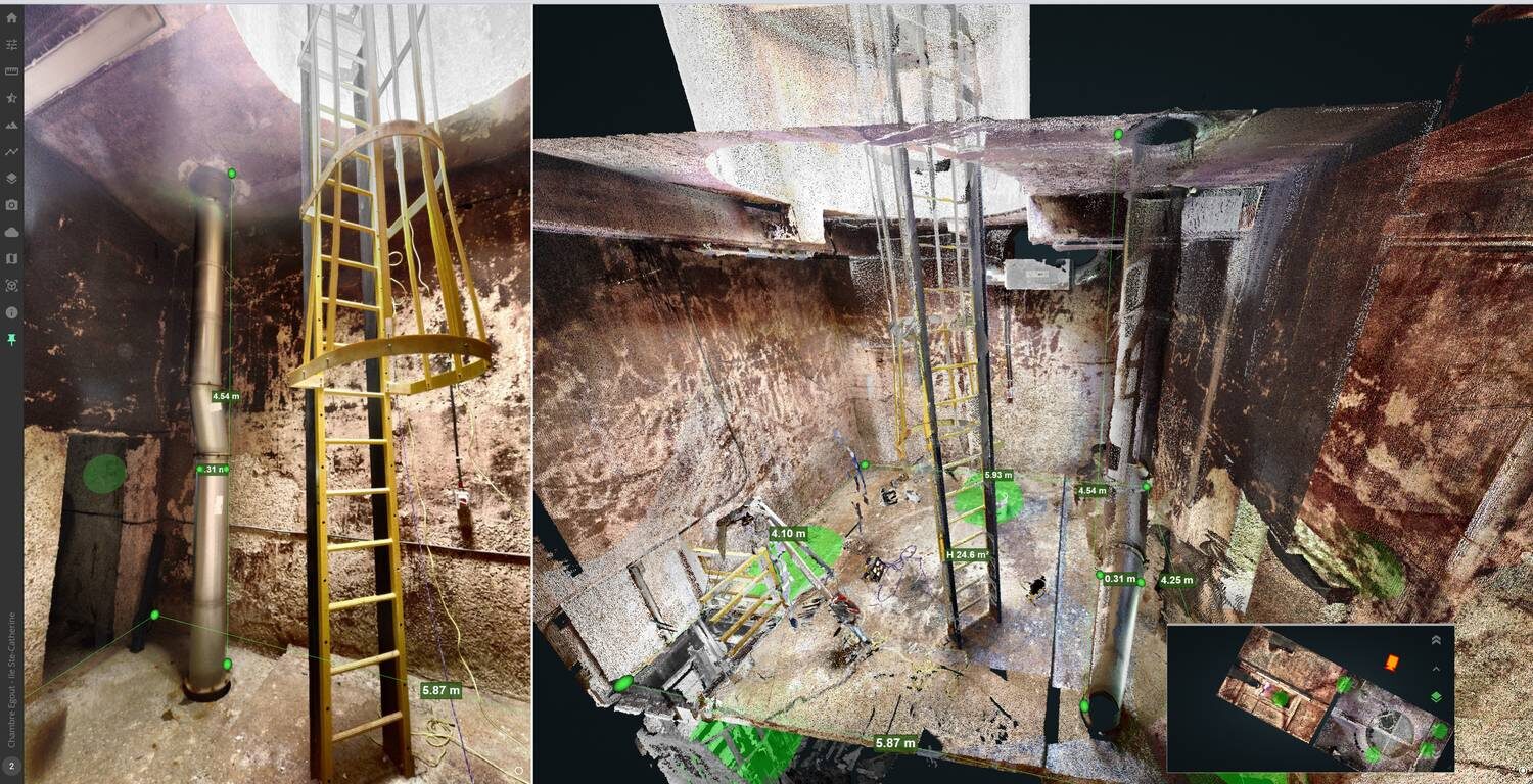
Vectorize, cut sections and export to CAD/GIS directly on VL365, so the heavy cloud never has to travel again.
Desktop-to-cloud continuum
VisionLidar for processing, VL365 for diffusion. One vendor covers capture to client deliverable, end to end.
The results
The quarter of the weight, without compromising the data
Hosted point cloud data
Same projects, same coverage, before and after the migration
Time
Publishing a project no longer means shuttling hundreds of station files. One LAZ, one trajectory set, one upload. Field-to-shared went from a background chore someone had to babysit to a routine the team barely thinks about. And reviewers open projects in a browser instead of requesting file transfers.
With 75% less data to stream, projects open faster in VL365, navigation stays fluid even on big sites, and jumping from station to station is near-instant. A quarter of the weight means the viewer has a quarter of the work to do, and the whole team feels it every day, on every project.
And notice the step that's missing: no mesh. No converter. No processing queue. Drag and drop into the browser, native Leica and FARO formats included, and the data is there. Usable, immediately. No downtime, nobody waiting for a platform to “prepare” the project. Engineering teams open it and work. That's the value.
Money
The old model billed by the scan position: every station, every setup, another line on the invoice, regardless of whether that position weighed 100 MB or 1 GB. The cost of hosting was welded to the intensity of the fieldwork. VL365 severs that weld. Scan as densely as the project demands; the platform doesn't count your tripod setups. Combined with a 75% lighter archive, CIMA+ turned a cost that scaled with their ambition into one that finally behaves.
Lighter data, lighter bill. And yes, lighter footprint
This isn't a green slogan; it's arithmetic. Every terabyte in the cloud is powered, cooled and replicated 365 days a year. Store 30 TB less and the bill follows, and so does the footprint: the cheapest, cleanest terabyte is the one you never store.
Challenges and solutions
Every obstacle addressed
| Challenge | Solution |
|---|---|
| Billed by the scan position: cost welded to field effort, growing with every campaign | VL365 pricing independent of scan count: capture as densely as the project demands |
| Structured scans mandatory to keep images and points connected, zero format flexibility | Trajectory files + JPG spherical images preserve the image-to-point link in a light, unified format |
| 40 TB of duplicated structured data online | Unified LAZ export from VisionLidar: 75% smaller footprint on VL365 |
| Fear of losing quality by converting the archive | Precision, density and accuracy preserved, only the container changes |
| Mixed sources: terrestrial, mobile and SLAM scanners (.lsproj/FLS and E57) | All imported natively into one VisionLidar desktop workflow |
| Sharing heavy data with reviewers and clients | Browser-based streaming on VL365: no downloads, no desktop licence for viewers |
| Data stuck in mesh conversion and processing queues before anyone could work | Drag & drop in the browser, native formats (Leica, FARO…): no mesh, no converter, data usable immediately |
| Unpredictable transfer costs when moving data | Unlimited upload/download included on VL365 |
| Upcoming mobile mapping and drone campaigns multiplying volumes | Static, mobile and airborne scans all feed the same unified pipeline, one standard for every sensor |
What CIMA+ gained
Beyond the storage cut
The migration was about terabytes. What the team discovered afterwards is what makes them stay.
Open LAZ = no lock-in
The archive now lives in an open, universal format. Any future tool can read it. Leaving is easy, which is exactly why nobody needs to.
SaaS or on-premises
VL365 deploys in the cloud or inside your own walls, with OpenID Connect single sign-on. Critical for public infrastructure clients with data sovereignty rules.
Roles & access control
From simple viewer to power user: give clients, reviewers and subcontractors exactly the access they need, nothing more.
Annotate & document (POI)
Pin points of interest with notes, photos, hyperlinks and documents: the point cloud becomes a living asset register, not just a picture.
Revit's working partner
Point clouds are too heavy for Revit. Engineers model in Revit with VL365 open in parallel: the survey-grade cloud in a browser, no import, no decimation.
Profiles & cross-sections
Cut, save and share sections with the whole community, analysis that used to require a desktop seat.
CAD & GIS plugins
AutoCAD Map and ArcGIS Online connect directly to VL365 projects: measure in the viewer, land it in your drawing.
VR-ready viewer
The full web viewer is compatible with virtual reality headsets: walk clients through a site from the meeting room.
LAS & RCP export from the browser
Select any area and export it in LAS, or in RCP (ReCap) for Revit workflows. The right slice, the right format, generated on demand.
Your brand, your domain
Pro package lets you serve the platform under your own logo and domain name: the client sees you, not the software vendor.
World map organization
Pin every project on a map, group by theme, filter with the search engine: a proven way to keep hundreds of sites findable.
Still paying by the tripod?
Your archive is 4× heavier than it needs to be, and your invoice shouldn't depend on how many times you set the scanner down. See what your library becomes on VL365: same precision, a quarter of the footprint, total format freedom.
Learn more