
VisionLidar365 – Web Point Cloud Sharing Platform
Designed to facilitate collaboration on 360-degree images and point clouds, VisionLidar365 offers a range of tools to streamline processes, including vectorization, data extraction, and asset documentation and management. By enhancing workflows with easy sharing and analysis of complex 3D data, VisionLidar365 helps users save time and resources.

Architecture, Engineering
AND Construction

MANUFACTURING

HYDRO & UTILITIES

RAILWAYS

TRANSPORTATION

MUNICIPAL
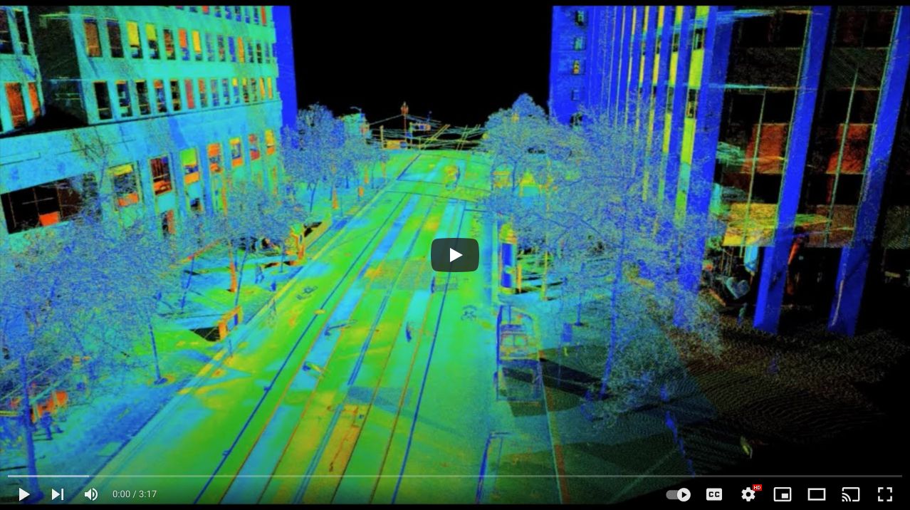
Our Lidar Software VisionLidar365 is a powerful Web Point cloud Sharing Platform with plenty of benefits.
Our Lidar Software, VisionLidar365, is moreover an exceptional Web Point Cloud Sharing Platform. As a top-tier Lidar Software, it offers an array of powerful features and benefits. With VisionLidar365, you have a versatile solution for managing and sharing point cloud data notably on a Web Point Cloud Sharing Platform.
Digital Twins
You can always Access your Digital twins with ease through VisionLidar365. It facilitates smooth navigation through your projects within a 3D environment from the comfort of your office. However, this approach allows you to immerse yourself in the Internet of Things (IoT) today, reaping the benefits of a top-tier solution for managing your assets and point cloud data.
High Capacity
Share limitless high-quality point cloud data with our Lidar Software VisionLidar365. This software is essential for professionals who need accurate information for their projects. Additionally, you can visualize your Spherical images in an immersive view and validate the accuracy of your vectorization and interpretation. This helps you in getting the maximum of your high-resolution data.
Customizable
VisionLidar365 is highly customizable. Its interface gives users the best working experience on navigating through large amount of 3D data. Pin your data in a world map, organize your data by thematic, use multiple view window the get the maximum of your data. Regardless of what industry you work in, the application is flexible enough to tailor your needs.
Unlimited Upload/Download
Elevate your LiDAR workflow with VisionLidar365, a web-based point cloud sharing platform. Additionally, this advanced software ensures seamless and limitless download/upload experiences, fostering uninterrupted creative processes. Moreover, with lightning-fast speeds and high bandwidth capabilities, it optimizes efficiency for swift and reliable LiDAR data transfers. Furthermore, VisionLidar365 empowers your team to work at the speed of LiDAR innovation, offering a unified solution for efficient and high-performance point cloud data management.
User Friendly Time Saver
Our Lidar Software combines advanced features with user-friendly accessibility, suitable for diverse users. Additionally, set roles easily, from simple viewer to power user. Moreover, the intuitive interface and helpful features enhance usability. VisionLidar365 is a cost-effective, time-saving solution for efficient analysis and vectorization, meeting tight delivery schedules. Furthermore, it consolidates lidar projects, saving time and money, maximizing workforce value, and streamlining point cloud data management.
However, it’s good to note that Our Lidar Software VisionLidar365 is an invaluable Web Point Cloud Sharing Platform for professionals looking to increase productivity, improve accuracy, and streamline their projects. Its powerful features, combined with its user-friendly design, make it an excellent choice for a range of different industries and applications. In addition to its robust functionality, it offers a cost-effective solution that can significantly benefit your projects.

Obtain a personalized quote for our Lidar Software tailored to your unique requirements
Additionally, boost your productivity with VisionLidar365, our Web Point Cloud Sharing Platform, available in multiple package options.

MANAGE

BROADCAST

EXPLORE

EXPLOIT
Enhance Your Workflow with the Advanced Features of our Lidar Software VisionLidar365.
Consequently, explore how VisionLidar365 elevates your work process with its advanced capabilities.
Do you want to
Engage in Point Cloud Processing?

POINT CLOUD PROCESSING SOFTWARE
Time to Try out VisionLidar365 Lidar Software Free Viewer
Check out the free viewer of our Lidar Software VisionLidar365. Additionally, fill out the form below and get ready to start processing and sharing Point Cloud on the web! Notably, begin your journey with VisionLidar365 by exploring its free viewer. Just complete the form below and prepare to process and share Point Cloud data on the web.
Organizations that utilize our Lidar Software VisionLidar365, including government agencies and businesses
We are grateful to all of our dedicated customers, both within and outside of our country, who have partnered with us over the years and use our Lidar Software VisionLidar 365. We appreciate your trust and support. However, our deep appreciation goes out to our loyal customers, whether they’re located domestically or internationally. Your trust and continued support mean a lot to us.